Land for sale in Bakewell DE45, 0 Bedroom
Quick Summary
- Property Type:
- Land
- Status:
- For sale
- Price
- £ 10,000
- Beds:
- 0
- County
- Derbyshire
- Town
- Bakewell
- Outcode
- DE45
- Location
- Land At Magpie Mine, Sheldon, Bakewell DE45
- Marketed By:
- Bagshaws
- Posted
- 2024-04-01
- DE45 Rating:
- More Info?
- Please contact Bagshaws on 01629 347964 or Request Details
Property Description
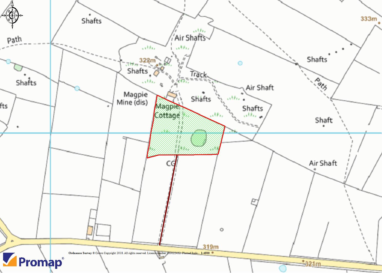
The opportunity to purchase approximately 3.92 acres (1.59 hectares) of this high-profile former mining site.
For sale by Informal Tender, all tenders to be received no later than 12 noon on
Friday 17th May 2019.
Location
The land is located on the outskirts of the village of Sheldon in the Peak District National Park approximately 3.7 miles from the market town of Bakewell and 9.4 miles from the spa town Of Buxton.
Directions
Coming from Bakewell town centre take the left hand turning onto the B5055 road. Follow the road for just over 2 miles and take the next right after Bolehill Farm Cottages onto the road signposted for Sheldon, Flagg and Chelmorton. Follow the road and take the sharp bend to the left stay on the same road and take the next right turning, follow the track and the land is located on the left and right approximately 200 metres down the track.
Description
Accessed down a stoned track off the road lies approximately 3.92 acres (1.59 hectares) of undulating grassland and a small parcel of woodland adjacent to Magpie Mine.
The site is a scheduled ancient monument. The land is stock proof bounded by stone walls.
Basic Payment Scheme
The land is in a Higher Level Stewardship scheme, the Peak District Historical Mines Society are currently liable for the hls.
Viewing
The land may be viewed at any reasonable time when in possession of a copy of these particulars.
Restrictive Covenants
To use the property only as an upland limestone pasture in perpetuity managed primarily for its ecological biodiversity.
Not to damage or disturb any groundworks or other relics associated with historic mineral activities evident in the property and to abide by the requirements for management of the scheduled ancient monument.
Not to use the property or any part of it for any purpose permitted pursuant to Part 4 of Schedule 2 of the Town and Country Planning (General Permitted Development) Order 1995 or any equivalent or replacement of it (including but not limited to leisure activities, events or for parking of vehicles and trailers).
Not to make any alterations or to erect any buildings or carry out any development on the property or bring any caravans, camping pods or other structures on to the property.
Not to carry out or permit tipping or dumping or storage of materials or waste at the property.
Services
No services are connected to the land. Any interested parties should make their own enquiries.
Rights Of Way, Wayleaves & Easements
The property is sold subject to and with the benefit of all rights of way, wayleaves and easements whether or not defined in these particulars.
There is a private right of way that crosses the land for the benefit of third party land and access the mine site. A right of way for the benefit of the property is shown by way of a solid brown line on the plan. A public footpath also crosses the land.
Overhead electricity apparatus crosses the site on a typical wayleave that is scheduled for undergrounding.
Timber, Mineral & Sporting Rights
Timber, mineral and sporting rights are reserved to a third party.
Tenure & Possession
The property is sold freehold. The Peak District Historical Mines Society holds a periodic annual fbt over the fields.
Vendors Solicitor
Deborah Shaw
Email:
Tel:
Planning Authority
Peak District National Park, Aldern House, Bakewell, Derbyshire DE45 1AE. Tel:
Local Authority
Derbyshire Dales District Council, Town Hall, Bank Road, Matlock, Derbyshire, DE4 3NN, Tel:
Method Of Sale
The property is offered by way of informal tender. All bids must be submitted on the prescribed tender form and must be received by 12 noon on Friday 17th May 2019 in an envelope that is clearly marked ‘Tender – Land at Magpie Mine’ enclosing the informal tender form.
Agents Notes
Bagshaws llp have made every reasonable effort to ensure these details offer an accurate and fair description of the property but give notice that all measurements, distances and areas referred to are approximate and based on information available at the time of printing.
These details are for guidance only and do not constitute part of the contract for sale. Bagshaws llp and their employees are not authorised to give any warranties or representations in relation to the sale.
Property Location
Marketed by Bagshaws
Disclaimer Property descriptions and related information displayed on this page are marketing materials provided by Bagshaws. estateagents365.uk does not warrant or accept any responsibility for the accuracy or completeness of the property descriptions or related information provided here and they do not constitute property particulars. Please contact Bagshaws for full details and further information.


